


GPS Locations

คำอธิบายของGPS Locations
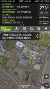
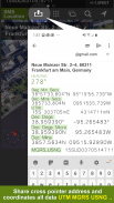
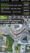
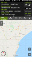
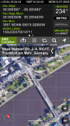
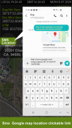
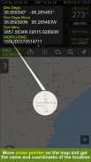
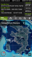
GPS Locations shows your current location, date & time to the second along with a scrollable map. You can copy your coordinates & locate anything you can find on the map with accurate crosshairs.
Have a telescope that needs your coordinates & the current time? Need to know the coordinates for your hunting stand? Going on a trek and need to find your lat/long? Want to scroll around the world and see where your favorite landmarks are? GPS Locations is what you need.
After launch, the map automatically centers on your location. Elevation is shown feet & meters. Your phone's time is shown in Greenwich Mean Time (aka Zulu time). To recenter the map on your location, just hit the crosshairs button.
*Coordinates of the map's center are shown in next formats:
- Dec Degs (DD.dddddd˚)
- Dec Degs Micro (DD.dddddd "N, S, E, W")
- Dec Mins (DDMM.mmmm)
- Deg Min Secs (DD°MM'SS.sss")
- Dec Mins Secs (DDMMSS.sss")
- UTM (Universal Transverse Mercator)
- MGRS (Military Grid Reference System)
ตำแหน่ง GPS จะแสดงตำแหน่งปัจจุบันวันที่และเวลาของคุณไปยังตำแหน่งที่สองพร้อมกับแผนที่ที่เลื่อนได้ คุณสามารถคัดลอกพิกัดและค้นหาทุกสิ่งที่คุณสามารถหาได้บนแผนที่ด้วยกากบาทที่แม่นยำ
มีกล้องโทรทรรศน์ที่ต้องการพิกัดและเวลาปัจจุบันของคุณหรือไม่? ต้องการทราบพิกัดสำหรับจุดล่าสัตว์ของคุณหรือไม่ ไปช่วงระยะการเดินทางและต้องการค้นหา lat / long ของคุณหรือไม่ ต้องการเลื่อนดูโลกและดูว่าสถานที่สำคัญที่คุณชื่นชอบอยู่ที่ไหน? ตำแหน่ง GPS คือสิ่งที่คุณต้องการ
หลังจากเปิดตัวแผนที่จะจัดตำแหน่งของคุณโดยอัตโนมัติ ระดับความสูงแสดงเป็นฟุต & เมตร เวลาของโทรศัพท์ของคุณจะแสดงในเวลามาตรฐานกรีนิช (เวลาของ Zulu) หากต้องการเลื่อนแผนที่ไปยังตำแหน่งของคุณอีกครั้งเพียงกดปุ่มกากบาท
* พิกัดของศูนย์กลางแผนที่แสดงในรูปแบบถัดไป:
- Dec Degs (DD.dddddd˚)
- Dec Degs Micro (DD.dddddd "N, S, E, W")
- ธ.ค. นาที (DDMM.mmmm)
- Deg Min Secs (DD ° MM'SS.sss ")
- Dec Mins Secs (DDMMSS.sss ")
- UTM (Universal Transverse Mercator)
- MGRS (ระบบอ้างอิงตารางทหาร)

GPS Locations - ข้อมูล APK
เวอร์ชั่น APK: 3.7.2แพ็คเกจ: com.narkira.gpslocationเวอร์ชั่นล่าสุดของGPS Locations
เวอร์ชั่นอื่น


 4.63
4.63


 3.55
3.55


แอปในประเภทเดียวกัน


